Evolving Regions - Innovative and interactive tool for regional climate impact analysis
- Projects
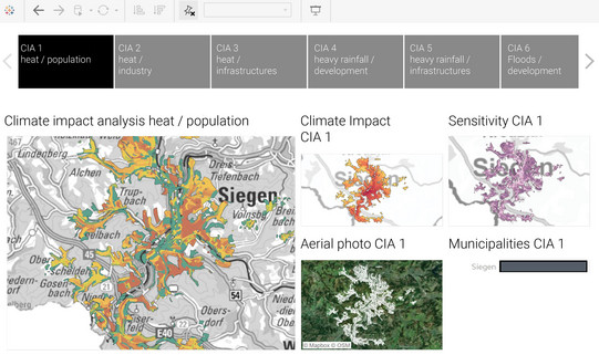
The current status of the climate impact analyses was presented and actively applied in the first four regions of Evolving Regions, namely Wesel, Steinfurt, Siegen-Wittgenstein and Soest, as part of the roadmap process. The results were jointly discussed in online workshops and compared with the perceived impact and empirical values. The participants found that the wide range of climatic and spatial data as well as the innovative and interactive tool, Tableau (see the figure), very helpful and goal-oriented. In the next step, measures will be developed under the direction of the Sozialforschungsstelle Dortmund (TU Dortmund), and the Deutsches Institut für Urbanistik based on the findings obtained and spatially located with the help of the analyses.
Parallel to the ongoing roadmap process, more detailed data was collected for the climate impact analyses in the districts and associated municipalities. These are now being incorporated into the new version of the climate impact analyses, which will include a wider range of sensitivity data as well as future projections regarding climatic and spatial developments. Furthermore, the remaining three districts of Coesfeld, Minden-Lübbecke and Lippe are currently starting the process in which the climate impact analysis will also be used as an evidence basis.
In addition to the work within the regions, the knowledge gained in terms of content and methodology was further disseminated within the framework of a consultant training course. In the international context, a method comparison with the approach of the Dutch region took place, using the results for improvements of the ER methodology and especially the visualisation.


